Monday, September 19, 2011

Pelling:Spending Days with Lord Buddha

0 comments
Pelling is a hill town of West Sikkim and located at the altitude of 7,200 feet or 2,150 meter. Besides, this hill town is situated around 135 km away from Siliguri and 115 km away from Gangtok. Majority of the inhabitants of Pelling are Buddhists and the languages used here are Nepali, Sikkimese, English and bengali.

Mode of transport:


A regular bus service connects the town with Gazing, the district headquarter. Another mode of transport in Pelling is the jeep service. This service joins Pelling with kalimpong, Jorethang and Namchi. Now a days, with the huge increment of tourists footfall, the town is going through a metamorphosis with setting up new hotels and repairing roads. The nearest airport of this town is the Bagdogra airport. Tourists can reach in this hill town through flights too.
About Pelling:

From the quarters and guest houses of Pelling, the mighty views of Kanchenjunga and Himalayas are seen. Sometimes, tourists can also experience the magnificent view of the snow capped peaks of the Himalayan range such as the Koktang, Rathong, Kumbhakarna, Zopuno, Narsing, Dom, Kabru and many more. Pelling also works as a base of the peripatetic adventurers and the trekkers, who undertake a arduous and strenuous treks in the other parts of West Sikkim. The adjacent area of Pelling are still a virgin territory and this part is enriched with numerous hillsides and alpine vegetation. In the winter season, Pelling gets covered with a snow blanket. 
 
Tourist destinations in Pelling:


Pelling is not well known for the tourist destinations. Rather, this town is known for its silent beauty. If you are tired of the city's hustle and bustle, and want to relax your mind, then Pelling can be the best place. It is not that there are no places to visit in Pelling. The popular tourist destinations are:
  • Pemayangtse Monastery: It is one of the most important and oldest monasteries of Sikkim. It was founded in the year 1705, and have a great collection of sculptures and wall paintings in it. Every year, in January or February, a traditional religious dance “cham” is performed in the premises.
  • The Khechuperi or Khecheopalri lake: Covered by the rich forests at every side, this lake is considered as the most sacred lake of Sikkim.
  • Sangachoeling Monastery: located behind the pelling town, this monastery is enriched with a great view of the surrounded mountains. Thisw monastery was built in the year 1697, and considered as one of the oldest monasteries of Sikkim.
Other known tourist locations are: rock garden, the local monastery, waterfall near Rimbi, Singshore bridge-the archaic quaint, Chhange bridge, Kanchenjunga falls, Rinchenpong, Yuksom, Hee Burmiok and Dzongri.

Ideal time to visit Pelling:


Pelling is ideal for the tourists at anytime of the year except the monsoon. Tourists should carry warm cloths in the winter seasons and light woolen clothes during the summer days. Carring an umbrella can be helpful.

Saturday, September 10, 2011

Rajasthan is a desert jewel historical, cultural, custom, traditional, royal & imperial state of India

0 comments
Rajasthan is a desert jewel, cultural, historical, traditional, custom, imperial and royal state of India. The heritage tradition of hospitality of Rajasthan is really unforgettable. People are helpful and kindhearted and they assist the tourists in all possible ways. Precious custom and culture has made this state one of the most attractive tourist destinations in the world. The heritage and royal state of Rajasthan has loads of attractive things to offer the tourists. Idealistic stylish palaces, amazing forts, marvelous architectural antique temples, marvelous havelis with chromatic, murals,and miniature paintings, colorful festivals and fairs etc. are the prime assets of Rajasthan. Every year a large number of tourists comes to this state from all over the world visit this this state.

History of Rajasthan


During the period of 700 AD Rajput clans emerged in Rajasthan and began to hold their control and to spread their influence over various parts of Rajasthan. Before the emergence of the Rajput clans, the city was a part of various small states. It was also a part of the Mauryan Empire. Hunas, Malavas, Guptas, Saka, Kushans, Satraps, Yaudhyas, Malavas and Arjunyas are some of the other republics which ruled this region.
In the history of Rajput clans, the dominance was during the period of 8th-12th century AD. At this period of 750-1000 AD, Rajasthan and most part of the northern India was governed by the Pratihars. During 1000-1200 AD, the ancient land of Rajasthan witnessed the dominance struggle between Chlukyas, Parmars and Chauhans.
During 1200 AD the most parts of Rajasthan was under the Muslim rulers. Ajmer and Nagaur were the main centers of powers. Ranthambhor was under their control too. From the very beginning of 13th century, Mewar came out as the most prominent and powerful state of Rajasthan.
Before the control of Mughal emperor Akbar, Rajasthan was never been politically united. Akbar first established a united part of Rajasthan. The Mughal power started to drop after 1707. After the declination of the Mughal Empire, the Marathas became the rulers of Rajasthan.
In 1755 Marathas took their control over Ajmer. In this period Rajasthan was also attacked by the Pindaris. After that, the British Government finished the alliance agreements with about all the territories of Rajputana in the year 1817-18.and from that time Rajasthan was known as Rajputana till the pre independence time. After being independent in the year 1947, the state attained its present name Rajasthan.

Places to Visit in Rajasthan

Ajmer
The city was found by Raja Prithviraj Chauhan in the 7th century and it is located 120 km or 78 miles west of Jaipur..

Ajmer is famous for the “Dargah of Khwaja Muin-ud-din Chisti” (1142-1236) and “Ana Sagar Lake”. The city is also well known for the famous Sophia college boarding schools and Mayo college .


Alwar
Alwar is a beautiful city located 143 km from Jaipur, 164 km from Delhi,.160 kms from Udaipur.
 
Banswara
Located 160 kms from Udaipur and 527 km from Jaipur, Banswara is a small town which is famous for the Baneshwar Festival.


Bharatpur


Located at 175 kilometer from Jaipur & 185 kilometer from Delhi, the city is known for the base on the way of Agra as well for the Keoladeo Ghana National Park or bird sanctuary. Bharatpur used to be ruled by the Jats. The museum and old fort are also there.


Bikaner


The city of Bikaner is situated in the way of Jaipur to Jaisalmer and it was founded by Rao Bika in the 15th century. The city is well known for carpets, durries, mojari slippers and hand printed lamp shades. Tourists can visit the Junagarh Fort located in the city and can ride the camel ride.


Bundi


Bundi is located at 40 km from Kota and 206 km from the city of Jaipur. the city is enclosed by the Aravalli hills on the three directions and also confined by a huge wall with four entrances.

Chittorgarh

The city of Jaipur was found by Bappa Rawal in the 8th century. The city is located 110 km away from the city of Udaipur and 300 km away from the city of Jaipur. Chittorgarh is famous for the huge 495 feet high and three mile long fort. Mirabai, the saint and poet of the 16th century was from this city. This city is also known for Rani Padmini, kirtistambha and Vijaystambha. The fort of Chittorgarh has also witnessed jauhars and three brutal seizes.


Dungarpur


Dungarpur also known as the city of hills. The city was found in the 13th century and it is situated at 110 km south of the city Udaipur. Juna Mahal is one of the reknowned tourist destinations of this city and it is adorned with beautiful paintings, frescoes, glass inlays and mirror works. The government of this state runs the Somnath temple and the Rajmata Devendra Kanwar Museum.


Jaipur


Jaipur is known as the "Pink City". Located 250 km away from Delhi, the city the capital of Rajasthan as well the starting point of the tour to Rajasthan. The city is famous for Jantar mantar, Amber Fort, Hawa mahak, Sisodia Rani's bagh and City Palace. The place is also famous for the block prints for the textiles, handicraft items, semi precious jewelry and Man dhir.


Jodhpur
Situated at 250 km away from Jaipur, the city of Jodhpur is also known as the “Blue City”. Jodhpur was found by Rao Jodha and it is well known for Umed Bhawan Palace, Mehrangarh Fort, handicrafts and museums.


Jaisalmer
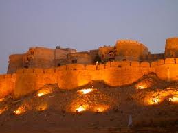
Located 275 Km away from Jodhpur, the city is also called "Golden City". The city was founded by Rao Jaisal. Jaisalmer is well known for the sand dunes, Patwon-ki-haveli and also ideal for safaris and camel rides.


Jhalawar


Situated at 87 km from Kota and 335 km from Jaipur, the princely state Jhalawar was established in the 1838 A.D.


Kota


This city is situated 131 km away from Ajmer and 240 km away from Jaipur. The city is known for the Dussehra Mela.


Kumbhalgarh


Located 85 km away from Udaipur, Kumbhalgarh is well known for Kumbhalgarh Wildlife Sanctuary.


Mount Abu
Located 27 Km away from Abu and 190 Km away from Udaipur is a hill resort of Rajasthan. The city is well known for Guru Shikar, Dilwara Temple and Nakki Lake.


Nathdwara
48 km from Udaipur in Rajasthan lies the popular relegious place, Nathdwara.


Ranakpur
Ranakpur is one of the most important pilgrimages of Jainism. The city is also the home to the beautiful temples in the Aravali ranges 


Rohet
The city of Rohet is famous for the local traditions and cultures. It is situated 160 km away from Udaipur and 212 km away from Indore.
Sariska


Sariska is well known for a Tiger Reserve Sanctuary and it is situated at 35 km away from Alwar and 110 km from Jaipur.


Ranthambore
Ranthambhore is well known for the Tiger Reserve Project, Ranthambore National Park. It is located at 11 km away from Sawai Madhopur and 135 km away from Jaipur.


Amer Palace


The Amer Palace was built by Raja Man Singh in the 16th century. The palace is an amazing blend of both Mughal and Hindu architecture. Rajputs have used the palace from 16th century till the year 1727 for both defense purposes and for the purposes of residence.


City Palace
Located at the capital of the state Rajasthan, the Jaipur City Palace is one of the chief palaces. It is a wonderful fusion of the conventional Mughal and Rajasthan architecture. The huge complex of the palace appoints one seventh part of the Jaipur city.


Dargah Sharif


Also known as 'Holy Dargah', the place is one of the most divine Muslim shrines of India. Admired by both Muslims and Hindus, the dargah is the grave of a Sufi saint Khwaja Moin-ud-din Chisti, who was from Persia and donated his life for the the betterment and service of the downtrodden and poor.


Fateh Sagar Lake


The Fateh Sagar Lake is located at Udaipur and in the north part of the Lake Pichola. Maharana Jai Singh built the lake in the year 1678 by as a enduring storage reservoir. Three sides of the lake were enclosed by holls and one side was by Pratap Memorial, the lake presents a charming scenery.


Havelis of Jaisalmer


The wonderful mansions made of sandstone of the wealthy merchants of Jaisalmer are said as 'havelis'. In most of the elaborated homes a poem is etched out in the sandstone with various pains and details, together pieced and carved in various patterns, and they are also loud and lavish in nature,


Hawa Mahal
Hawa Mahal” or “Palace of the Wind” was built up by Maharaja Sawai Pratap Singhon 1799. The Hawa Mahal is basically an expansion of the women's chambers. Soon, the mahal has become one of the great landmarks of Punjab.


Jantar Mantar
Jantar mantar is the name of any magical device in Sanskrit. The building was named after Jantar Mantar because of the big masonry appliances, which are kept in this palace to check 'the harmony of the heavens' appreciated by the Sawai Raja Jai Singh II. The building took seven years to get completed.

Puskar
Pushkar is a great Hindu pilgrimage and it is said that a single dip in the holy lake is similar to the visit of four Hindu Shrins known as the Chaar Dhaam'. The three sides of this beautiful loke is enclosed by the hills and the other side is by sand dunes. Every year a cattle fair is held in this place in October or November.

Sahelion Ki Bari
This place is also known as the Garden of the Maids of Honor' was a beautifully planned garden along with shady walks and extensive lawns. The garden was located on the bank of Fateh Sagar Lake and it used to be reserved for those royal ladies who used to go for a stroll. Maharana Sangram Singh had constructed this garden in the 18th century.


Shrinathji Temple
Located 48 km away from Udaipur, the Shrinathji temple is situated amidst some idyllic hills. It is basically a temple of lord Krishna and his structure hollowed out of a black marble. According to the experts, this temple is the second most prosperous temple in the world.

Tuesday, August 16, 2011

Kerala -cultural-historical and geographical State

0 comments
Kerala is a most popular state in South India. It was establish on 1st November 1956 by the States Reorganization Act, and it combined various Malayalam speaking regions. Spreading across an area of 38,863 km sq Kerala shares its borders with Karnataka in the north, Tamil Nadu in the south and the Lakshadweep in the west. Kerala also a state in Southern India is known as a tropical paradise of waving palms and wide sandy beaches. It is a narrow strip of coastal territory that slopes down the Western Ghats in a cascade of lush green vegetation, and reaches to the Arabian sea. Thiruvananthapuram is the captal of the state Kerala, it's also known as Gods Own Country Kerala is the favorite tourist spot of many Indian and foreign travelers.

There are 14 districts in Kerala. Based on certain cultural, historical and geographical similarities the districts of Kerala are grouped into; Malabar Region North Kerala), Kochi Region (South Kerala) and Travancore (Central).

Kerala become a favorite tourist place in India, over the years it is a popular tourist destination for its backwaters, yoga, Ayurveda treatments,coconuts, spices and art forms like Kathakali and Mohini Attam and tropical greenery natural beauty also touch our heart.

Kerala is the most literate state in India, and a land of diverse religions, where you can find Hindu temples, mosques, churches, and even synagogues.
Kochi is located on the western banks of the Arabian Sea and it is an important port city in Kerala. Travelling to Kerala by train is very easy. Kerala is connected to the other states and cities in India. Kerala Railway Network consists of almost 200 stations spread throughout the state. Kerala connects extremely well with major cities like Bangalore, Mumbai, Chennai, Kolkata, and Delhi and by 13 different railway routes. Traveling by train to Kerala can be said to be the most inexpensive and quick means of transportation.

Munnar is the most important hill stations in south India. Situated on the banks of the Nallathanni Muthirappuzha and Kundaly rivers Munnar rightly gets its name from the Tamil words Munnu meaning Three and Aaru meaning River. Covering an area of 557 km sq this mesmerizing hill resort is one of the major causes behind the successful tourism in Kerala.


Kollam is a small city located on the boundaries of the Astamudi Lake. Kollam is also a famous tourist hub in Kerala. It is situated at a distance of 71 km from Thiruvananthapuram. Kollam serves as the southern gateway to the backwaters of Kerala. It is also the fourth largest city in Kerala and is also a major commercial hub of the state.

Kottayam is an important industrial town in Kerala. It is situated at a distance of 150 km from Thiruvananthapuram, the state capital. This was the first municipality of India to achieve the 100 percent literacy mark. It also became the first Indian state district to ban tobacco.

Although Kerala is a part of India but Kerala Culture and Festivals are quite unique and different. The major cause for its extraordinary culture is that Kerala has been a place where people from different religious beliefs and cultures have mingled and co existed in harmony since centuries. Even the states geographical location contributes to a large extent to its culture.

Kannur is a historical town famous for its strong heritage, martial arts 'Kalaripayattu', temple art 'Theyyam', political movements, forts, beaches and spices/coffee growing hills.

Kozhikode is a most prominant city of Malabar area,where Vasco da Gamma landed for the first time in India, and one of the world's oldest thriving trade centres. A very clean city known for its friendly inhabitants.

Palakkad is a gateway of Kerala by land through the Palghat Pass in Western Ghats; known for its paddy (rice) fields, hills, traditional homes, cuisines and composite culture. Tipu Fort, Malampuzha Gardens, Silent Valley National Park are nearby.

Thrissur is the cultural capital of Kerala and also famous for jewelery shops and silk sarees. Temple festivals with caparisoned elephants like Thrissur Pooram. Athirappilly falls, Guruvayur Temple are nearby.


Wednesday, July 13, 2011

Lavasa is the first planned Hill Cities in India

0 comments
Lavasa is the first planned Hill Cities in India, Lavasa is located in the western mountain ranges of India, the area is located behind the 20 kms long Dam/ Lake of Varasgaon and it is quite close to the major cities of Pune and Mumbai. Lavasa is just about 65 Kms (an hrs drive) from Pune and abut 200 Kms ( 3.5 hrs) from Mumbai.

Lavasa is surround by the mountains region and valleys,it is most popular for it's location and place,here people found many opportunities like mountain climbing, hiking and trekking. The popular attractions here include the Lake shore, which offers opportunities of adventure sports like boating against the strong currents of the lake, cruises and jet skiing. Lavasa also balanced life in harmony with nature and an inspirational destination for lifestyle seekers.

Lavasa is set on the seven hills of Maharashtra in the Mose valley. The city was planned and built as per the principles of ecological sustainable environment and urbanization. The city is equipped with all the latest means of technologies and facilities, the Master Plan of Lavasa has been developed by internationally renowned design consultant HOK, USA which are being managed by HCC India.

Lavasa is a hub for world-class educational institutions, hospitality and training centers, it's an arena for the mind where learning is a way of life.

The weather conditions in Lavasa remain throughout the year. The best time to visit Lavasa is during the monsoon season because of the pleasant weather that allows the exploration of natural wildlife and waterfalls located in the region.

Lavasa offers a refreshing and pleasant climate remain throughout the year with vast open spaces provides innumerable recreation and leisure activities like golf, trekking, rappelling to satiate the adventurer in you.

Lavasa is at its magical best during the monsoon season. The rains arrive, bringing with them the promise of months filled with pattering showers, lush green hills with many waterfalls playfully tumbling down them, and days are spent looking out at the rain through a wet window, smiling at a paradise that has been found. After the showers pass, the entire countryside is alive with freshness.

Lavasa can be reached from Pune, which has the nearest airport at a distance of 49 kilometres from Lavasa. The airport of Pune is connected to nine other Indian cities. The other airports located nearby are Chhtarapati Shivaji International Airport (CSIA) of Mumbai, located around 215 kilometres. The recently constructed airport at Panvel is located 145 kilometers away.

Monday, May 2, 2011

Nainital the lake city

2 comments

Nainital is a town in the Indian state of Uttarakhand and headquarters of Nainital district in the Kumaon foothills of the outer Himalayas. Nainital is a precious jewel in the Himalyan necklace. Nainital also known as the lake city and lake district of Uttarankahd, it is located around the Naini Lake. This place is named after the Goddess Naini Devi, the presiding idol of the area. Nainital is a popular summer retreat of India, Nainital attracts so many tourists during the summer heat. There are few other lakes around Nainital which are equally beautiful and attractive as the Naini lake.River Ramganga originates from the Doodha Tauli ranges in district Pauri Garhwal. It enters into district Nainital, before re-entering into district Pauri Garhwal. It is renowned for its lake, bird's-eye views, and prestigious educational institutions.
Nainital is located in the Kumaon hills and the weather is very pleasant throughout the year except during winter months. The temperature is not very high at any time but in winters it becomes very cold. The climate of Nainital is regulated by the lake here which showers rain almost every afternoon. The best time visit the place is between April to June and then again in September October. The months of January to March are marked by the snowfall which is for a very short time.Some of the important places in the district are Nainital, Haldwani, Kaladhungi, Ramnagar, Bhowali, Ramgarh, Mukteshwar, Bhimtal, Sattal and Naukuchiatal. Nainital’s unending expense of scenic beauty is nothing short of a romance with awe-inspiring and pristine Mother nature.

Tuesday, March 1, 2011

Kedarnath

0 comments
Kedarnath is one of the Char(4) Dham a very holy pilgrimage destination for all Hindus at Uttarakhand in India. Kedarnath range stands one of the famed Jyotilirlingam of Lord Shiva. Lying at an altitude of 3.581 mts. above the sea level. It is the remotest of all the chardham sites surrounded by some of the most beautiful snow capped mountains. The present temple was built back in the 8th century AD by Adi Shankaracharya is next to the site of an earlier temple that legend says was built by the Pandavas of the Mahabharata. The samadhi (final resting place) of Adi Shankaracharya is located behind the main shrine. The temple is made out of gigantic, evenly cut grey slabs of stone, and the inner walls of the assembly hall are decorated with figures of several deities and mythological scenes. Just outside the temple stands a large statue of Nandi Bull as a guard. Kedarnath Temple is believed to be more than 1000 years old.

Many other place are also very beautiful to viewers from kedarnath like Chorabari (Gandhi Sarover), Vasuki Tal, Gaurikund , Triyuginarayan, Deoria Tal etc.

Chorabari (Gandhi Sarover)

According to Hindu Legends, Gandhi Sarovar is a small lake from where Yudhishthir, you take enjoy camping at himalaya hills the eldest of the Pandavas is believed to have moved to heaven. The floating ice on the sparkling waters is an amazing sight that attracts tourists from all over the country and abroad.


Vasuki Tal
Located about 4135 meters above sea level and surrounded by lofty mountains, Vasuki Tal is a picturesque lake which offers a commanding view of the Chaukumbha peaks.


Gaurikund
To reach Kedarnath, Gaurikund is the main trekking base. From Gaurikund, there is a 14 kms long stretch after which the pilgrims reach Kedarnath.


Triyuginarayan Temple Triyuginarayan
Triyuginarayan, 5 kms trek from Sonprayag is the mythological place of marriage of Lord Shiva and Goddess Parvati. It is believed that an eternal flame which is said to have been a proof to their marriage burns in front of the temple even today.


Deoria Tal

Sari Village on the Chopta-Ukhimath road is the last bus terminus from where a 2 km trek leads to Deoria lake. Situated at an altitude of 2348 meters, this beautiful lake gives the spectacular reflection of the snow capped mountains in the lake water. If you are a nature lover then this is the right choice.


Kedarnath is approachable on foot from Gaurikund, which is directly  connected by road to Rishikesh, Kotdwar, Dehradun, Haridwar and other important hill stations of Garhwal and Kumaon region. The closest rail connection is at Rishikesh (234 km from Kedarnath and at Kotdwar (260 km from Kedarnath). he closest airport is the Jolly Grant in Dehradun (251 km from Kedarnath). The best time to visit Kedarnath is between May-October as during the winter season it gets closed.Many ashrams and dharamshalas provide cheap accommodation. There are also many private hotels and restaurants although most have only basic facilities. Also beware that Kedarnath can be extremely crowded during peak pilgrim season. The state-run guest house is generally booked throughout, so arrive early if you want options.

Thursday, January 6, 2011

Leh Ladakh

0 comments
In case you are planning to go to Ladakh on a vacation, you must be looking for some travel tips such as weather conditions of Leh Ladakh, the best time to go there, how to reach. We trying to provide some information related to Ladakh . Ladakh is the mountainous region of Jammu and Kashmir. Bounded by two of the world's mightiest mountain ranges, the Great Himalaya and the Karakorum, the area known as the Trans-Himalaya. The settled population live between 2700 m and 4500 m. it's the largest and the least populated region of Jammu and Kashmir.Temperatures in Ladakh, range from-3 to 30 degrees Celsius in the summer and from -20 to 15 degrees Celsius in the winter.The people are a mixture of Buddhist and Muslim.Buddhists are the majority in the east close to the Chinese border and a slight majority overall while Muslims have the majority in the north and west . Ladakh is a region in India totally isolated from the modern world. Ladakh means "land of high passes". Until the coming of the aircraft, the only access into this remote, high Trans-Himalayan kingdom was across several high pass crossings. From the west the Zoji La at 14,000 feet is the lowest. Taglang La to the southeast is17,200 feet high and a military highway now crosses this coming from Manali. To the north is the Khardung La - at 18,200 feet, the only access into the Nubra valley and the Karakorams. Dead ends now,
but important in centuries past, were the northern passes on the Central Asian trade route - Saser La and the Karakorum pass.From November to May, Ladakh is almost completely cut off from the outside world.Even in summer, getting here involves crossing the highest mountain passes in the world, or a hair-raising flight that weaves between the peaks.Tourism and hydro-electric power are flooding the region with money, and global warming is altering rainfall patterns, threatening farming cycles and Ladakh’s traditional mud-brick architecture.You need to be physically fit to undertake a tour to Leh Ladakh. It is advisableto take at least 12-24 hours of rest after reaching Leh to fully acclimatize to the high altitude. If you feel shortness of breath, nausea, dizziness, or fatigue, immediately take some rest. Always carry drinking water,chocolates or energy bars while traveling.Medicines, moisturizers and sun-screen lotion are a must when traveling to Leh Ladakh. Since Ladakh is on India's sensitive north western border, the movement of foreign tourists is restricted in some areas of Ladakh. Foreign tourists may not travel beyond one mile north of the Zoji-la-Dras-Bodhkarbu- Khalatse road, except to visit the monasteries of Tia-Tingmosgang, Rizong, Likir and Phyang. Shey, Thikse, Chemrey and Tak-thok monasteries lying north of the Leh-Upshi road can also be visited. The Leh-Manali road is also only open upto one mile east of its general alignment. Foreign
tourists can visit some newly opened areas in north eastern and northern regions of Ladakh, but only with permission of the Deputy Commissioner Leh.In present times, the only two land routes to Ladakh in use are from
Srinagar and Manali. Travelers from Srinagar start their journey from Sonamarg, over the Zoji la pass (3,450 m, 11,320 ft) via Dras and Kargil (2,750 m, 9,022 ft) passing through Namika la (3,700 m, 12,140 ft) and Fatu la(4,100 m, 13,450 ft.) This has been the main traditional gateway to Ladakh since historical times. However, with the rise of militancy in Kashmir, the main corridor to the area has shifted from the Srinagar-Kargil-Leh routevia Zoji la to the high altitude Manali-Leh Highway from Himachal Pradesh. The highway crosses four passes, Rohtang la (3,978 m, 13,050 ft), Baralacha la (4,892 m, 16,050 ft), Lungalacha la (5,059 m, 16,600 ft) and Taglang la(5,325 m, 17,470 ft), and is open only between July and mid-October when snow is cleared from the road. There is one airport in Leh, from which there are multiple daily flights to Delhi on Jet Airways, Air Deccan, and Indianand weekly flights to Srinagar and Jammu. Buses run from Leh to the surrounding villages. There is about 1,800 km (1,100 mi) of roads in Ladakh of which 800 km (500 mi) is surfaced. The Manali-Leh-Srinagar road makes upabout half of the road network, the remainder being spurs off it. Ladakh is criss-crossed by a complex network of mountain trails which, even today provides the only link to most of the valleys, villages and high pastures.For the traveler with a number of months it is possible to trek from one end of Ladakh to the other, or even from places in Himachal Pradesh. The large number of trails and the limited number of roads allows one to stringtogether routes that have road access often enough to restock supplies, but avoid walking on motor roads almost entirely.

Vietnam vacation with Vietnam Vision Travel - Vietnam Tour Operator offers private vacations, customize tour, adventure tours, excursion, special packages, beach holidays, family packages, cycling tour program in Vietnam.